2 miles
Distance
136 ft
Climb
-466 ft
Descent
00:13:55
Avg time
Anns (East) Details
-
Riding AreaCorner Canyon
Draper, Utah -
Difficulty Rating
-
Trail TypeSingletrack
-
Trail UsageMulti-use
-
DirectionBoth Directions
-
Climb DifficultyBlue
-
Physical RatingModerate
-
Dogs AllowedYes
-
eBike Allowed
-
Global Ranking#193 in Mountain Biking
-
Local Popularity85 in Mountain Biking [+]
- 95 in E-Biking
- 5 in Trail Running
- 5 in Hiking
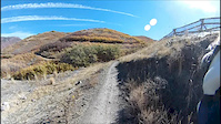
This trail is a nice gradual climb from Potato Hill Trailhead or a mostly flowying downhill from Peak View. There are some exposed sections and some of the tight turns can be a bit narrow. This is marked as easy, but for some young kids or beginners there are some sections that may be more difficult. Traffic goes both ways and is a heavily used trail by many user types. Most riders go up this towards Peak View, though riders will be coming down fast especially where it washes out a bit near Anne's Point.
Local Trail Association
-

-
Corner Canyon Trails Foundation
(www.cornercanyontrails.com) Please consider joining or donating to the local riding association to support trail development & maintenance.donate to earn trail karma!
More Stats for Anns (East) bike trail
-
Altitude change-330 ft
-
Altitude min5,515 ft
-
Altitude max5,845 ft
-
Altitude start5,845 ft
-
Altitude end5,515 ft
-
Grade-2.84%
-
Grade max-22.5%
-
Grade min28.802%
-
Distance climb2,646 ft
-
Distance down2 miles
-
Distance flat644 ft
-
Avg time00:13:55
-
Avg reverse time00:18:28
- view trail stats
close
Trail Conditions
- Unknown
- Snow Groomed
- Snow Packed
- Snow Covered
- Freeze/thaw Cycle
- Icy
- Prevalent Mud
- Wet
- Variable
- Dry
- Very Dry
Trail Ridden Direction
Trailforks scans users ridelogs to determine the most popular direction each trail is ridden. A good flowing trail network will have most trails flowing in a single direction according to their intension.
The colour categories are based on what percentage of riders are riding a trail in its intended direction.
The colour categories are based on what percentage of riders are riding a trail in its intended direction.
- > 96%
- > 90%
- > 80%
- > 70%
- > 50%
- < 50%
Trail Last Ridden
Trailforks scans ridelogs to determine the last time a trail was ridden.
- < 2 days
- < 1 week
- < 2 weeks
- < 1 month
- < 6 months
- > 6 months
Trail Ridden Direction
The intendid direction a trail should be ridden.
- Downhill Only
- Downhill Primary
- Both Directions
- Uphill Primary
- Uphill Only
- One Direction
ContributeDetails
Colors indicate trail is missing specified detail.
- Description
- Photos
- Description & Photos
- Videos
LEGEND
Trail Difficulties
Trail Report Status
- Access Road/Trail
- White
- Green
- Blue
- Black
- Double Black Diamond
Trail Report Status
- Clear / Green
- Minor Issue / Yellow
- Significant Issue / Amber
- Closed or Major Issue / Red
- Land Owner Overlay
- Wilderness (typically no bikes in USA)
- BLM (public)
- USFS (Wildlife sanctuaries darker than usfs)
- State land
- Indigenous
- Military
Trail Conditions
- Unknown
- Snow Groomed
- Snow Packed
- Snow Covered
- Freeze/thaw Cycle
- Icy
- Prevalent Mud
- Wet
- Variable
- Dry
- Very Dry
- Map Markers
 Trail Head
 Photo
Photo Directory Listing
 Riding Area
 TTF
TTF Parking
 Viewpoint
 Information
 Warning
 Directions
 Water Fountain/Source
 Sight
Sight Restrooms
 Gate
Gate Camping
 Trail Sign
 Table or Bench
 eBike Charging Point
 Other
Other
Directions to anns-east trailhead
(40.488220, -111.820700)
update trails status or condition
Anns (East) Trail Reports
view all reports »
Recent Ridelog Activity on Trail
Past Week
- 0 rides
6 Months
- 628 rides
- 11 miles avg distance
All
- 10,157 rides

Photos
more »
Routes with this trail
more »
-
+ 1
This trail has good flow east to west, but watch for two-way traffic.
[Reply]
Good riding on Anne’s in both directions. Popular with hikers though, so watch out.
[Reply]
Videos
more »
13:51 |
268 |
Mar 5, 2015 , Draper
Nearby Trails
- rush flow 0 ft
- ventricle 112 ft
- brocks point 115 ft
- peak view th 220 ft
- the trees 1,496 ft
- embed Anns (East) trail on your website
- By todd Trailforks Plus & contributors
- #11963 - 3,419 views
- subscribe
- login to download gpx or kml files.
Open trail in mobile app