3 miles
Distance
681 ft
Climb
00:30:08
Avg time
Trail Supporters, Builders & Maintainers of Badger Pass Trail
BLMLand Manager
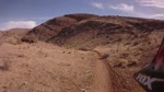
Badger Pass Details
-
Riding AreaCottonwood Valley
Las Vegas, Nevada -
Difficulty Rating
-
Trail TypeSingletrack
-
Dogs AllowedYes
-
Global Ranking
-
Local Popularity100 in Mountain Biking [+]
- 5 in Trail Running
- 95 in Hiking
No description for Badger Pass trail has been added yet! Submit one here.
Local Trail Association
-

-
Southern Nevada Mountain Bike Association
(snmba.org) Please consider joining or donating to the local riding association to support trail development & maintenance.donate to earn trail karma!
More Stats for Badger Pass bike trail
-
Altitude change681 ft
-
Altitude min3,952 ft
-
Altitude max4,634 ft
-
Altitude start3,952 ft
-
Altitude end4,634 ft
-
Grade4.435%
-
Grade max0.692%
-
Grade min10.113%
-
Distance climb3 miles
-
Distance flat47 ft
-
Avg time00:30:08
- view trail stats
close
Trail Conditions
- Unknown
- Snow Groomed
- Snow Packed
- Snow Covered
- Freeze/thaw Cycle
- Icy
- Prevalent Mud
- Wet
- Variable
- Dry
- Very Dry
Trail Ridden Direction
Trailforks scans users ridelogs to determine the most popular direction each trail is ridden. A good flowing trail network will have most trails flowing in a single direction according to their intension.
The colour categories are based on what percentage of riders are riding a trail in its intended direction.
The colour categories are based on what percentage of riders are riding a trail in its intended direction.
- > 96%
- > 90%
- > 80%
- > 70%
- > 50%
- < 50%
Trail Last Ridden
Trailforks scans ridelogs to determine the last time a trail was ridden.
- < 2 days
- < 1 week
- < 2 weeks
- < 1 month
- < 6 months
- > 6 months
Trail Ridden Direction
The intendid direction a trail should be ridden.
- Downhill Only
- Downhill Primary
- Both Directions
- Uphill Primary
- Uphill Only
- One Direction
ContributeDetails
Colors indicate trail is missing specified detail.
- Description
- Photos
- Description & Photos
- Videos
LEGEND
Trail Difficulties
Trail Report Status
- Access Road/Trail
- White
- Green
- Blue
- Black
- Double Black Diamond
Trail Report Status
- Clear / Green
- Minor Issue / Yellow
- Significant Issue / Amber
- Closed or Major Issue / Red
- Land Owner Overlay
- Wilderness (typically no bikes in USA)
- BLM (public)
- USFS (Wildlife sanctuaries darker than usfs)
- State land
- Indigenous
- Military
Trail Conditions
- Unknown
- Snow Groomed
- Snow Packed
- Snow Covered
- Freeze/thaw Cycle
- Icy
- Prevalent Mud
- Wet
- Variable
- Dry
- Very Dry
- Map Markers
 Trail Head
 Photo
Photo Directory Listing
 Riding Area
 TTF
TTF Parking
 Viewpoint
 Information
 Warning
 Directions
 Water Fountain/Source
 Sight
Sight Restrooms
 Gate
Gate Camping
 Trail Sign
 Table or Bench
 eBike Charging Point
 Other
Other
Directions to badger-pass trailhead
(36.011110, -115.431400)
update trails status or condition
Badger Pass Trail Reports
view all reports »
Recent Ridelog Activity on Trail
Past Week
- 7 rides
- 18 miles avg distance
6 Months
- 325 rides
- 16 miles avg distance
All
- 1,187 rides
Photos
more »
Routes with this trail
-
+ 0
The reward for BP is 3 Mile Smile! This trail is constant uphill with a slightly hairy downhill switchback at the end. If you've had enough, turn right for half of 3 mile smile or left for more uphill to top of 3MS.
[Reply]
This is a great trail and gives you two options, either Techno trail or 3 mile smile after a zig zagging descent, but well worth your time and effort!!!
[Reply]
Videos
more »
6:00 |
287 |
Aug 29, 2010 , Las Vegas
Nearby Trails
- latenight connector 3,363 ft
- viagra 3,363 ft
- old spanish 1 miles
- latenight trail 1 miles
- piggy 1 miles
- embed Badger Pass trail on your website
- By brenthillier NSMBA Trailforks Plus & contributors
- #5018 - 2,015 views
- subscribe
- login to download gpx or kml files.
Open trail in mobile app