5,025 ft
Distance
397 ft
Climb
-83 ft
Descent
00:19:09
Avg time
Barrel Roll Details
-
Riding AreaGlendo State Park
Glendo, Wyoming -
Difficulty Rating
-
Trail TypeSingletrack
-
Trail UsageBiking Primary
-
DirectionBoth Directions
-
Climb DifficultyBlue
-
Physical RatingModerate
-
Dogs AllowedYes
-
Global Ranking#33372 in Mountain Biking
-
Local Popularity60 in Mountain Biking [+]
- 5 in Trail Running
- 5 in Hiking
No description for Barrel Roll trail has been added yet! Submit one here.
Local Trail Association
- Please consider joining or donating to the local riding association to support trail development & maintenance.donate to earn trail karma!
More Stats for Barrel Roll bike trail
-
Altitude change314 ft
-
Altitude min4,505 ft
-
Altitude max4,830 ft
-
Altitude start4,505 ft
-
Altitude end4,819 ft
-
Grade6.25%
-
Grade max-56.7%
-
Grade min87.098%
-
Distance climb3,468 ft
-
Distance down1,055 ft
-
Distance flat502 ft
-
Avg time00:19:09
-
Avg reverse time00:22:46
- view trail stats
close
Trail Conditions
- Unknown
- Snow Groomed
- Snow Packed
- Snow Covered
- Freeze/thaw Cycle
- Icy
- Prevalent Mud
- Wet
- Variable
- Dry
- Very Dry
Trail Ridden Direction
Trailforks scans users ridelogs to determine the most popular direction each trail is ridden. A good flowing trail network will have most trails flowing in a single direction according to their intension.
The colour categories are based on what percentage of riders are riding a trail in its intended direction.
The colour categories are based on what percentage of riders are riding a trail in its intended direction.
- > 96%
- > 90%
- > 80%
- > 70%
- > 50%
- < 50%
Trail Last Ridden
Trailforks scans ridelogs to determine the last time a trail was ridden.
- < 2 days
- < 1 week
- < 2 weeks
- < 1 month
- < 6 months
- > 6 months
Trail Ridden Direction
The intendid direction a trail should be ridden.
- Downhill Only
- Downhill Primary
- Both Directions
- Uphill Primary
- Uphill Only
- One Direction
ContributeDetails
Colors indicate trail is missing specified detail.
- Description
- Photos
- Description & Photos
- Videos
LEGEND
Trail Difficulties
Trail Report Status
- Access Road/Trail
- White
- Green
- Blue
- Black
- Double Black Diamond
Trail Report Status
- Clear / Green
- Minor Issue / Yellow
- Significant Issue / Amber
- Closed or Major Issue / Red
- Land Owner Overlay
- Wilderness (typically no bikes in USA)
- BLM (public)
- USFS (Wildlife sanctuaries darker than usfs)
- State land
- Indigenous
- Military
Trail Conditions
- Unknown
- Snow Groomed
- Snow Packed
- Snow Covered
- Freeze/thaw Cycle
- Icy
- Prevalent Mud
- Wet
- Variable
- Dry
- Very Dry
- Map Markers
 Trail Head
 Photo
Photo Directory Listing
 Riding Area
 TTF
TTF Parking
 Viewpoint
 Information
 Warning
 Directions
 Water Fountain/Source
 Sight
Sight Restrooms
 Gate
Gate Camping
 Trail Sign
 Table or Bench
 eBike Charging Point
 Other
Other
Directions to barrel-roll-20805 trailhead
(42.478610, -104.944150)
update trails status or condition
Barrel Roll Trail Reports
no reports have been added for Barrel Roll yet, add a trail report.
Trail reports are used to indicate a trails current condition and inform builders and other riders about any issues on a trail.
Trail reports are used to indicate a trails current condition and inform builders and other riders about any issues on a trail.
Recent Ridelog Activity on Trail
Past Week
- 0 rides
6 Months
- 3 rides
- 15 miles avg distance
All
- 36 rides
Photos
more »
Routes with this trail
Reviews / Comments
No reviews yet, be the first to write a review or ask a question.
Use trail reports to comment on trail conditions.
Videos
more »
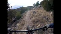
2:58 |
67 |
Nov 24, 2017 , Glendo
Nearby Trails
- twenty 15 965 ft
- wetlands 2 1,325 ft
- wetlands 2,005 ft
- thunder 2,044 ft
- lightening 2,346 ft
- embed Barrel Roll trail on your website
- By todd Trailforks Plus & contributors
- #20805 - 449 views
- subscribe
- login to download gpx or kml files.
Open trail in mobile app